Longitude and Latitude |
|||
Note:
|
|
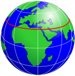
Lines of LongitudeA line of longitude is an imaginary line that extends from the North Pole to the South Pole of Earth. Each line is referred to by the angle between it and the line at 0 degrees longitude (known as the Greenwich Meridian). Each line is therefore known as an angle of longitude. |
|
Lines of LatitudeA line of latitude is an imaginary line that extends horizontally around the Earth. Each line is referred to by the angle between it and the line at 0 degrees latitude (known as the Equator). Each line is therefore known as an angle of latitude. |
Any position on Earth can be identified as the point where a line of longitude and a line of latitude intersect. This point is normally written in terms of these two angles, with an indication of whether the angle of longitude is East or West of the Greenwich Meridian, and whether the angle of latitude is North or South of the Equator.
|
Longitude and Latitude can be configured in the properties of the Workgroup (see Workgroup Configuration). This example shows a latitude of 51 degrees, 25 minutes and 0 seconds North of the Equator, and a longitude of 0 degrees, 13 minutes and 0 seconds East of the Greenwich Meridian. Angles are described in terms of three units: degrees, minutes and seconds. One degree is made up of 60 minutes. One minute is made up of 60 seconds. In an angle, the degrees are denoted by the symbol °; the minutes are denoted by ' and the seconds denoted by ". |